 |
 |
 |
 |
||||
|
|
|
|
|
|
|
|
|
|
|
|||||||
|
|
|
|
|
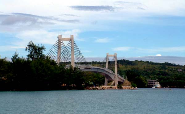
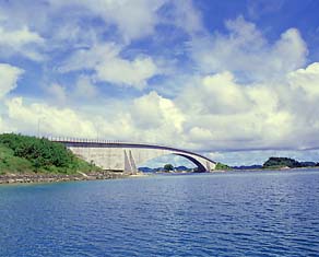
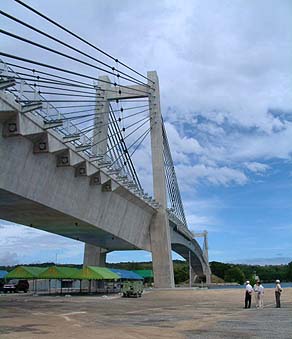
"I am not surprised about the bridge being built, because that is one of the few things that people who grow up in Airai used to dream about," Walter says. "Because it isn’t so far you know, Airai State from Koror State. Especially to people who’ve been outside of Palau and to other places. Even the Japanese, when they were here, they were showing us pictures of Japanese bridges everywhere, crossing the much bigger distances of land and water. But the people of Airai were just so few, just a small number of people, so we couldn’t afford to build a bridge just so you could talk to somebody from the other side."
|
||
|
|
||
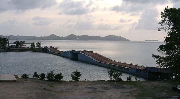
“The Japanese never built a bridge there. But the local people were dreaming about filling that channel so they could cross easily. Even when my father was alive, they were thinking that, well, we have so many big rock mountains, like the Rock Islands. If we could just bomb them and just fill that channel over there, then it would solve the problem. In those days, local residents were ferrying people from one side to the other side, using boats to Koror. "That channel is actually really hard to cross. I guess some people trying to swim across drowned and died going over. When the tide is going either in or out, the current is very strong. Especially after the Japanese built the causeways from both sides, that made it a little more narrow, so the current is even stronger today.
|
|
|
"That channel is also known for the blue shark—we call it metál. There are times of the day, and of the year, when they come closer, this bunch of them, and then they just attack anything that goes there. “We have this story about Yapese, who were in these islands a long way back. The way they tell it, this group of Yapese went over to the channel to cross it. And one of the guys from the group, he had all kinds of open sores on his skin. He was like a leper, or had some kind of skin disease. So they decided, ‘well, we are going to let him go first.’ They said, ‘he would go first and if the sharks get him, then we know, it is not safe, so we’ll just cancel the crossing.’ "So this guy, he went in and just swam across. And the salt water and the swimming action just washed all his sores clean, and spread that debris all over the area and created all kinds of smell for the sharks. But he made it across. And then one by one the others start going down saying, “well, its safe,” and they start swimming across."
|
|
|
|
|
“But now the sharks already know that there is food around, so right in the middle of the channel, they attack the rest of the group. That is how it supposedly happened. And the people in those days always tell about this story. "I always use this as an example, when people start swimming. Some people, they used to come to Koror to buy alcohol. But it was very hard for us to come over. Then a few of the guys would get drunk and would challenge each other to swim across to get the booze on Koror. And they always tell the story about the Yapese. Ah, they say to let this guy go first—they said, well he is sick so, if he crosses the channel, we will know it is safe and we’ll go. But it was a good way to attract the sharks."
|
||
|
|
||
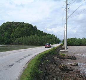
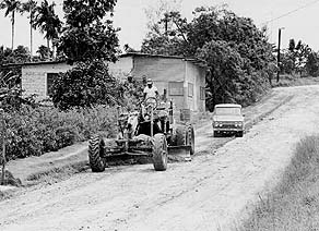
“Before the war, in Japanese times, there were cars over in Airai State. They brought them there—trucks and other things. The people in those days saw Palau as a much more developed and populated “Japanese” island. There were cars and trucks going to Babeldaob, so if you go to the center of Babeldaob today, like Ngetbang, in the boonies you can see the trucks and vehicles hidden in the jungle—they are still there. “When I was growing up, the road was just limestone gravel. There were no cars going back and forth to Airai Village. Some salvage company from Japan, once in a great while, they came and used a winch truck to salvage all the towers from the old communications buildings. And the bulldozers from World War II, they were used."
|
|
|
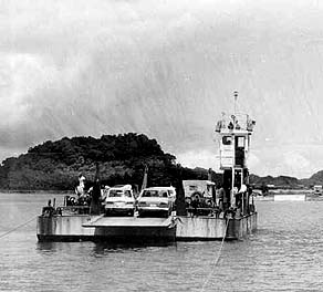
"But up until around the1960's when they started building the airport, they transported the vehicles across from Koror, using what they called M-boats, from the U.S. military, until we had the ferry boats. That is when we started seeing cars over here again. “Once the bridge went up, it greatly improved the way of life for the people of Airai. Transportation to Koror is much faster than it used to be. The way our government was built, everything was centralized in Koror. They aren’t doing much in the rest of Babeldaob, they just let the people over there come to Koror. "But there were very few people living in Babeldaob who were able to start a small store, like a nickel-and-dime store, and it helps those people in those far-away communities. There was really never any plan to bring whatever we have available here in Koror to the people in more remote areas. But that’s all right, they’re living much slower compared to Koror."
|
“Already during Japanese times, Airai, like Peleliu and Angaur, they took off from those influences, so they live much better than the rest of Babeldaob., If you compare Airai to the rest of Babeldaob now, you can see the difference because of the bridge. "But now the new road will connect all the way into Babeldaob, and then you will see the other villages in the rest of Babeldaob become more developed, with higher living standards too. They have much easier access to come and buy whatever is necessary for their living."
|
. |
|
|
|
|
“The airport on Babeldaob was initiated by the Japanese. It was one of the biggest projects. Almost all men from the Palau islands joined the work. But it got bombed just before it was completed.”
|
||
|
|
||
“According to the older people, they say that they heard that a noise coming, up in the sky, and they didn’t know what the heck was going on. Then they start seeing something flying over there and all they thought was it was people coming from the mainland—Japan—to maybe congratulate the work or whatever. They didn’t know what was going on. "And then the bombs started coming, and everybody just grabbed everything and they fled into the boonies. They were just running until they could not hear any noise. Everybody went crazy."
|
|
|
"Some workers had the pick axe on their back. There are some storyboards about this one guy. He went running into the boonies and the pick axe got caught in some vines. This guy was saying, 'hey, let me go, don’t hurt me.' "He thought somebody was holding him, and it was the pick axe that he was holding when he was running, and it caught in the vines, and he went in and out, in and out, he couldn’t let go."
|
|
|
|
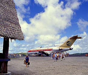
Palau International Airport, 2002.
|
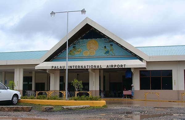
Then in the 1960's the American’s decided to complete the airport. They built and extended the runway—it wasn’t this long then—and they paved it. It was at one time just coral gravel. Before then we had only the seaplanes, the SA 16, an old propeller plane from the navy that landed in the water. They went to Peleliu. And then they came to the seaplane ramp at Meungs on Ngerekebesang. "It was very hard traveling. When you went to Guam, first you had to go to Peleliu by boat and stay there to wait for the plane the next day to take you over to Guam. And there weren’t that many boats, only the government boat, and it took maybe several hours to get to Peleliu. Is wasn’t like today with the speed boats."
|
||
|
|
||
Those SA16’s, when they went to Guam, I think it took about 6 to 7 hours to fly there. I’ve seen some old pictures of them anchored in mangroves in Yap. And they said when you are up in the air on your way to Guam, if it rains, the plane leaks. Water coming in, maybe through the seals around the windows . It was rough. It was just a propeller plane. They’re just open doors. "After that then we got the much better version of planes coming to Palau, in the 1970's. When I went to Guam I was in a propeller plane. There was still no asphalt on the runway, the surface was still just coral gravel. They took us about 2 hours faster then, a five-hour flight to Guam."
|
|
|
|
|
|
While the K-B Bridge and the airport opened Airai to Koror and the rest of the world, a different bridging was taking place on the other side of Airai traditional village. People from Oikull side were coming over and settling into what would become the new village of Airai.
|
||
|
|
||
|
|
|
|
|
|

|
| Airai Home | Map Library | Site Map | Pacific Worlds Home |
|
|
|
|

|
 |
|
|
|||
| Copyright 2003 Pacific Worlds & Associates • Usage Policy • Webmaster |
|||